
Return to Division 22's Home Page.
Videos and Self-Study Lesson Reinforcers
Posted by: Robert Kothe
Disclaimer: Division 22 and the Coast Guard Auxiliary do not endorse, recommend, or get any enrichment from any private businesses or other sources of videos and training resources. This group of videos and resources were selected because the lessons covered are in alignment with the teaching and testing related to the boat crew program. In other words … Our webmaster thinks these videos can help you learn.
Division 1 South Training Videos Link Page. Please note that Division 1 South has their training videos under password protection. Use the same login you would use for this page. Since the videos featured below are not security sensitive such as knot tying, there is no need to protect these pages.
Division 1 South Video Page Link
United States Coast Guard Auxiliary - D1SR (uscgaux.info)
https://wow.uscgaux.info/content.php?unit=014&category=public-edu
Includes:
Types of characteristics of lines
Heat Stroke Identification and how to react. The Today Show.
Being on the water it is important for Boat Crew members to look after themselves and each other to guard against heat related mishaps. Heat Stroke is very serious. Call 911.
Heat Stroke: Signs To Look For And How To Treat It (youtube.com)
https://www.youtube.com/watch?v=Qog3GveRj40
---------------------------------------------
ICS Overview
Let’s not forget that the Coast Guard Auxiliary is part of the national ICS (Incident Command System). It is important to understand the purpose and features of the ICS so we can lend our resources within a multi-agency situation.
On a smaller level, the principles of ICS can and should be used with single-agency and individual missions.
The following video is a broad overview of the ICS system:
https://www.youtube.com/watch?v=P-dPBso2xPM
------------------------------------------------------
Navigation and Plotting Videos
The foundation and basis for plotting is Latitude and Longitude. The following video is well produced, visual and short enough to enjoy.
Video: Lattitude and Longitude.
Link: https://www.youtube.com/watch?v=swKBi6hHHMA
USCG Auxiliary Note: The above video says that lines of latitude are approximately 69 miles apart and in boat crew we say it is 60 Nautical miles apart. The fact is that miles and Nautical miles are two separate scales 1 nautical mile is 1.15078 miles and 1 land mile is 0.868976 Nautical miles. When you convert it, you get roughly 60 Nautical miles is 69.0468 Land miles. Always pay attention to what scale you are using. We plot in Nautical miles.
USCG Auxiliary Note: The video says that Lines of Latitude are Approximately 69 miles apart. as explained above, this fact is true however in Boat crew we use the number 60 Nautical miles apart since a Knot in speed is 60 Nautical Miles in an hour, there are 60 minutes in a degree and there are 60 seconds in a Minute. On the distances, speeds and scale of the operations that the Auxiliary operates using Nautical Miles.
-------------------------------------------------------------------------------------------------------------
How to read a nautical chart: These gentlemen do an excellent job explaining a lot of important aspects about reading a chart. Worth the watch.
How to read a nautical chart.
Full path of video: https://www.youtube.com/watch?v=F5K6Se_h5IU
------------------------------------------------------------------------------------------------------------
Chart #1 - Download from NOAA
We learn in Coxswain training that “Chart #1” acts as a
master guide to Chart symbols and reference information. It is worth
downloading a copy for both Boat Crew and Coxswain training since much of
identifying and understanding a nautical chart is explained in Chart #1.
Since files and downloads change, the link below takes you to
the page where you can download the latest Chart #1.
Click here for the Chart #1 Download Page
The link for Chart #1 is towards the right on the top.
----------------------------------------------------------------------------------
Scale of the Chart
Size Matters. 1:25,000 Vs 1: 20,000 or 1: 500,000 Makes a big difference when you are buying or choosing your nautical charts. It is important to learn what scale a chart is and use caution based on that fact.
https://www.youtube.com/watch?v=bm0cwIGtvr4
Coast Guard Auxiliary Testing Hint: Be sure to know where to find information on your chart including Scale, Deviation, Low Tide Specs (Mean Low Low), Chart Number, where the scale is, the date the chart was printed and more. All this and more are fair game for your mentors and testers to expect you to find quickly.
------------------------------------------------------------------------------------------------------------
T. V. M. D. C. + W.
TVMDC is a principal boat crew needs to master.
VERIATION
You might think that your compass faces north, but the reality is that it actually faces towards a magnetic North pole that is off-center and even slowly moving. This is called “Variation”. The Variation for Chart 12365 is around 14 Degrees West.
DEVIATION
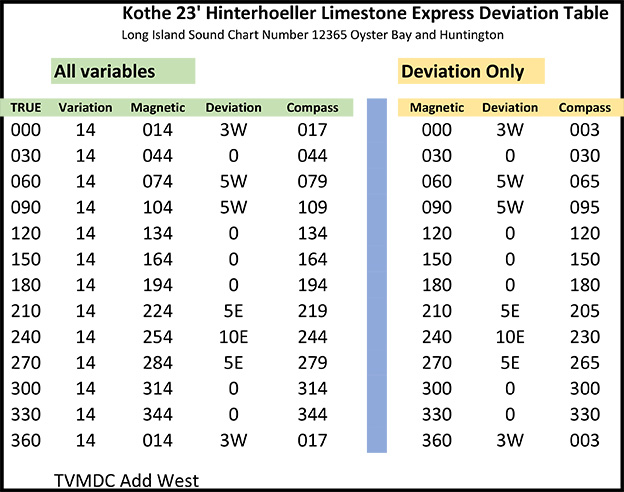
To make matters worse your compass probably cannot be trusted. Since electronics and magnetic fields are always messing with the magnetic reading. This is called “Deviation”. I am generalizing since all compasses are not created equal. Some boats have high-tech highly reliable ones and other boats have simple magnetic ones.
Each facility (Coast Guard Auxiliary Boat) owner is required to create a Deviation Table. The table helps us correct the Deviation by adding and subtracting for the known Deviation error.
This video teaches how to use TVMDC tables to calculate True north or perhaps the compass reading needed to find your destination despite Variation and Deviation.
TVMDC Video
https://www.youtube.com/watch?v=ffIwfvGFcpI
-----------------------------------------------------------------------------------------------------------------
60 “D” Street
60 D street is how we instantly remember and formulate three formulas to calculate Distance, Speed and/or Time. If you have 2 of 3 variables you can compute the rest.
This video is good and correct but it does not reflect the way our manuals show it so I will include another video that mirrors the boat crew program after it.
60 D STREET: How to calculate time, speed and distance in marine navigation. (youtube.com)
https://www.youtube.com/watch?v=SW1YP7_XyPs
This video is less polished but better reflects the boat crew program. The instructor does a better job at showing us how to extract the three formulas out of the 60 D Street pyramid.
------------------------------------------------------------------------------------------------------------
Converting from Degrees Decimal all the way to Degrees, Minutes, Seconds, Decimal
There is more than one way to skin this cat.
The first video is great if you understand fractions very well.
Converting from Minutes and Seconds to Degrees (youtube.com)
https://www.youtube.com/watch?v=UtgAAy-XvCQ
I personally like the method of drilling up or down by either Multiplying or dividing by 60 better illustrated in the second video.
https://www.youtube.com/watch?v=kbN93Q82IB4
Pay close attention to your chart is in degrees minutes or seconds or in Degrees, minutes and decimal minutes. If the smallest lines on the Longitude scale add up to 10 then you are in Degrees Minutes and Decimal Minutes. If the smallest lines add up to 6, you are in Degrees, Minutes and seconds. A good Mentor and/or tester will ALWAYS yry to trip you up and not knowing the difference will leave you VERY off-course.
TASK BCM-03-07-AUX: Tie Various Knots, Hitches, and Bends
Square Knot (Also Known as Reef Knot)
https://www.youtube.com/watch?v=LOAxiQk8wj8
Bowline (standalone)
How to Tie a Bowline Knot (youtube.com)
https://www.youtube.com/watch?v=YXRnPES0Qec
How to tie a Bowline around an object
Knots - How to tie a Bowline Knot around an object. (youtube.com)
https://www.youtube.com/watch?v=YuYdLAvvzRs
Clove Hitch
(1999) Learn How To Tie A Clove hitch Knot - WhyKnot - YouTube
https://www.youtube.com/watch?v=EKRFawQCP0Y
Clove hitch with a Half Hitch to lock
Tying a Clove Hitch with a Half Hitch | How to Tie (youtube.com)
https://www.youtube.com/watch?v=8wsEu-jPOXY
Half Hitches and Half Hitch with Round Turn
How to Tie a Half Hitch and Hitch Variations - ITS Knot of the Week HD - YouTube
https://www.youtube.com/watch?v=7rw6n_Qm194
TASK COXN-06-04-AUX: Plot the Following Search Patterns: Expanding Square (SS), Sector (VS)
Smarter Every Day – Explanation of the Sector Search VS (Victor Siera) Search pattern. Coxswains are required to chart out and run the Sector Search VS (Victor Siera) search pattern with the assistance of their crew members. This video is one of the best demonstrations of the VS drift pattern demonstrated on a U.S. Coast Guard Boat.
https://www.youtube.com/watch?v=aoXJfuPaFF8&t=75s
-----------------------------------------------------------------------------------------------------
Important VHF Radio Calls for Information and emergencies – Video Link
Any boater should be aware of how to make and receive emergency calls as well as how to share important information about non emergencies and Safety.
There are three devices used on the VHF radio called May Day, Pan Pan, and Securite.
In this video professional fishing guides and licensed boat captains, the Gale Force Twins will instruct on this verry information.
Click here for the Video:
-----------------------------------------------------------------------------------------------------