C. Sarasota Waterways
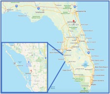 Sarasota is located on the southwestern coast of Florida between the southern end of Tampa Bay to north of Fort Myers. The islands separating Sarasota Bay from the Gulf are known as keys and include Lido Key and Siesta Key, which are famous for the quality of their sandy beaches.
Boaters headed into the Gulf, should become familiar with the passes through the barrier islands and the potential of unsafe shoaling, or hazardous shallowing of these passes. This is true especially in Big Pass and New Pass where navigation aids have been removed in part or entirely. Seek local knowledge of current conditions which are impacted by tide, weather, and unpredictable forces. Boaters unfamiliar with Big Pass or New Pass are advised to use the Venice Inlet to the south or Longboat Pass to the north instead. Below is information that is designed to help you navigate our waters and increase your safety and enjoyment.
Things you need to know
C.1 - Maps (Charts) of Sarasota Waterway - This section will provide links to useful charts and maps of our area. This includes: The Sarasota County Water Atlas, Chart 11425 which covers the Florida Gulf Coast from Tampa Bay to Charlotte Harbor, and the Local Notice to Mariners.
C.2 - Check the Weather - Being on the water during threatening weather can be extremely dangerous. And during the rainy season in southwest Florida, an afternoon storm can be experienced on most afternoons. Most of South Florida has a tropical climate. There is a defined rainy season from May through October on most days, when air-mass thundershowers that build in the heat of the day drop heavy but brief summer rainfall. This section provides links to obtain forecasts about local weather.
C.3 - Boating Laws and Regulations - Safe boating regulations can be confusing and vary if you are in state regulated waters (within 3 miles from the coast) or federal regulated waters (between 3 and 12 miles from the coast). This section provides links to state and federal boating regulations.
C.4 - Great Places to Visit - Sarasota County is a tourism destination. Visitors are attracted to our beaches, arts and culture, family attractions, and vast dining options. This link will take you to the Florida Water website, which provides a wealth of information about restaurants, boat ramps, marinas etc. LINK TO: FLORIDA WATER
C.5 - The importance of a "Float Plan" - Whether you are a power boater, or kayaker, the USCG Float Plan works for you. Set-up a basic plan ahead of time and save it on your computer. Retrieving and sharing a stored float plan or new float plan is easy with the USCG App mentioned below. Update it when you decide where and when you're going to go. Then email it to whoever you choose to follow up should you not return or check in as planned. LINK TO: FLOAT PLAN
C.6 - If you need Assistance - In the case of an emergency, you should call 911 or use your
VHF radio (Channel 16) to call for assistance. In the event of a breakdown, boaters have a number of private companies that will provide assistance. These companies can be contacted via phone or smart phone application. Having a VHF marine radio on board is highly recommended.
- Sea Tow - 800-4-SEATOW
- BoatUS800-391-4869 or hail Boat-US on Channel 16
C.7 - Marine Accident Report - Federal law requires the operator or owner of a recreational vessel to file a boating accident report with the State reporting authority if the recreational vessel is involved in an accident This section provides information on when and how an accident report needs to be completed.
C.8 - Reporting of missing or damaged navigational aids - The FWC operates the Marker On-Call Response Program to coordinate the timely examination, evaluation and appropriate repair of marker assets that represent a potential hazard to navigation. This type of response system provides an efficient notification process for directing personnel to evaluate issues and take appropriate action. In some cases, this may involve passing on reports of non-FWC-related waterway problems to another responsible entity such as the United States Coast Guard. Your assistance is greatly appreciated in reporting these situations.
Public Boat Ramps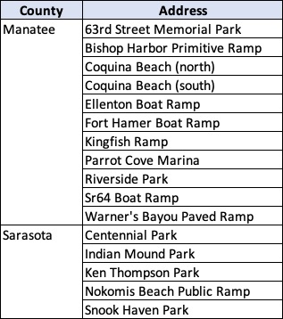
The Florida Fish and Wildlife Conservation Commission has provided a website with information about the public boat ramps in Florida. This includes a map on how to get there and pictures of the boat ramp.
The list to the right are the public boat ramps in Manatee county and Sarasota county.
LINKS TO: PUBLIC BOAT RAMPS
USCG Smart Phone App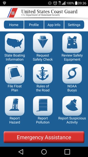
The USCG offers a smart phone application that provides quick access to a lot of the information discussed in this section. Download it and be better prepared to deal with situations that may arise.
Because cell phone service is questionable when you are out in our vast waters, it is strongly recommended that you have a marine VHF radio on board, in case you are broken down or have an accident.
If you haven't already down loaded it, we recommend you do so now.
USCG Aids to Navigation
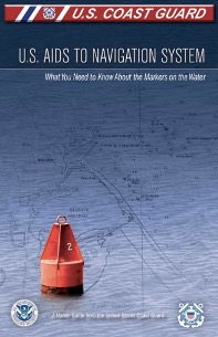 The U.S. Coast Guard has developed this brief pamphlet that packed with useful information that will help you use the tools and markers for navigating your journey. We recommend you print it and keep it in your boat.
Link to: U.S. Aids to Navigation System